
As Revealed through Pueblo Indian Architecture, History, and Tree Ring Lab Time Series.
Robert W Endlich
INTRODUCTION
During the presentation at the 21 March 2026 CASF meeting, Bill Gutman highlighted brief segments from the Joe Rogan Experience video which featured comments by Dr. Will Happer, emeritus Professor of Physics from Princeton, and Dr. Richard Lindzen emeritus Professor of Earth Atmospheric and Planetary Sciences from the Massachusetts Institute of Technology, https://open.spotify.com/episode/3ihn2aHDz9dyZU0T3Kylk3
The presentation featured several minute-long video segments, following which Bill Gutman paused the video, and asked topical questions to evoke discussion of the content by meeting attendees.
This post pertains to a couple of these segments, specifically the generally held perception by many, whose views have been formed many in the Mainstream Media that, because of human emissions of CO2 from fossil fuel use, weather is getting worse. These include, “tornadoes are worse, hurricanes are stronger, sea levels are rising faster,” claims made in the Fifth National Climate Assessment.
Here, we examine the claim that “droughts are worse” because of alleged “human-caused, CO2-fueled global warming,” as was proclaimed by the Los Angeles Times in, Climate Change Identified as main driver of worsening drought in the Western United States, from 7 Nov 2024, and this was hardly the only such claim.
What follows is a brief exploration of that latter, “droughts are worse,” especially when viewed from our ability to ferret out elements of climate and climate change from the history of Pueblo Indians who lived in the Colorado Plateau and surroundings, and left marks of their lives in their architecture and other artifacts.
MY RELATED BACKGROUND
I passed through Albuquerque in 1948 at age 8, spent a couple of days in Albuquerque in 1961, age 21 was stationed at Kirtland AFB in Albuquerque from 1970-1974, age 29-33, and worked at White Sands Missile Range from 1984-2011. I have visited many of the Pueblo Indian sites of New Mexico and Arizona over the years.
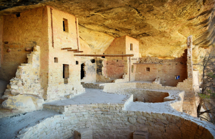
I first visited Mesa Verde National Park over Memorial Day weekend of 1970. Mesa Verde is home to probably the premier Pueblo Indian architectural marvel of the US, Cliff Palace. Cliff Palace was among the last developments of these stone-based dwellings found in Mesa Verde National Park.
SOME MESA VERDE HISTORY
From Wikipedia,
“starting c. 7500 BC Mesa Verde was seasonally inhabited by a group of nomadic Paleo-Indians known as the Foothills Mountain Complex. And, by 1000 BC, the Basketmaker culture emerged from the local Archaic population, and by 750 AD the Ancestral Puebloans had developed from the Basketmaker culture.”
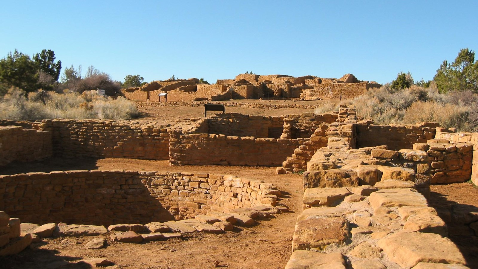
The Pueblo Indians’ first occupation of Mesa Verde appears to have been living in pit houses, some of which can be seen when visiting the mesa top sites, especially the Far View Sites. While visiting Mesa Verde National Park, it is possible to view the evolutionary development of Pueblo Indian architecture. Briefly, these people first lived in pit houses, then single-story homes above ground on the mesa top. The more famous examples are the cliff dwellings, not on the mesa top, but built later, and into the cliffs of the Mesa Verde Formation, such as Cliff Palace, and Square Tower House. For the purpose of this post, we’ll just consider the mesa-top structures of the Far View Sites, a good example of which is in Figure 1 below, an image from the National Park Service.
Excavations of the ruins indicate that a good number of the Puebloans remained living on the mesa tops, while others constructed the style more typical of the Pueblo III period, the multi-story dwelling style, found at Cliff Palace, Square Tower House and Oak Tree House.
The 13th century saw 69 years of below average rainfall in the Mesa Verde region, and after 1270 the area suffered from especially cold temperatures. Despite challenging conditions, the Puebloans continued to farm the area until a severely dry period from 1276 to 1299 ended seven hundred years of continuous human occupation at Mesa Verde. Archaeologists refer to this period as the “Great Drought”. The last inhabitants of the mesa left the area c. 1285.
There are relevant measures of rainfall and drought from both the popular literature and the technical literature. Let’s examine this particular one, displayed below in Figure 2, which derives directly from data collected from northwest New Mexico by scientists from the University of Arizona Tree Ring Laboratory.
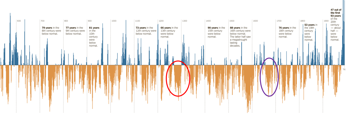
The University of Arizona Tree Ring Laboratory published a chronology of rainfall which was cited more broadly in the New York Times on 12 Aug 2012 with the title, “The Longest Measure of Drought: 21 Centuries of Rainfall in New Mexico.” A segment of that time series is Figure 2 above. These two significant drought periods are highlighted with the red and purple ovals in Figure 2.
The date 10 Aug 1680 is the first day of the Pueblo Revolt, where the indigenous peoples of what is now New Mexico rose up and threw out the Spanish colonizers, at least temporarily, for a dozen or so years. But the story starts earlier, because the drought in the 1670s helped cause widespread societal unrest aiding in setting the stage for the Pueblo Revolt. This line spells it out:
“In the 1670s drought swept the region, causing a famine among the Pueblo and increased raids by the Apache…”
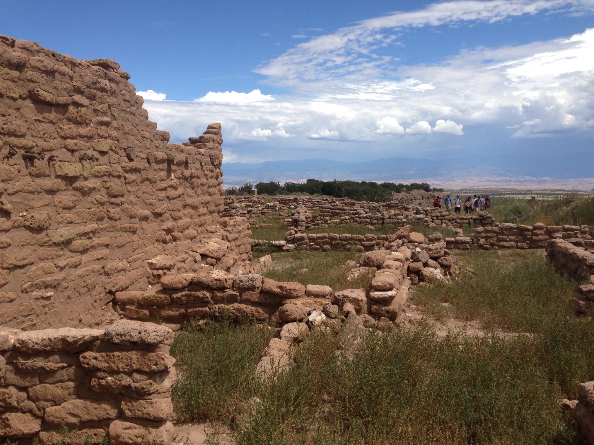
Another historical indicator of the severity of this drought comes from the Abo’ ruins, in central New Mexico and not far from the town of Mountainair, NM. Abo’ was a Pueblo Indian Settlement; the Spanish began missionary work there in 1622, and constructed a red sandstone church there, beginning in 1629. But drought became the dominant force and, along with Apache attacks, forced the Spanish to withdraw to Mexico about 1672. The remains of the church at Abo’ are a significant part of the present-day Salinas Pueblo National Monument.
So, the data clearly demonstrate that present levels of drought in the Mesa Verde area are nowhere near as severe as those in the late 1200s, the late 1500s, and the late 1600s, when drought forced the Spanish to leave their missions in New Mexico. This is another indication that present-day climate alarmists attempt to speak authoritatively on subjects of which they know little.
THE PUEBLO PEOPLE TODAY
In 2013 I visited the Puye Cliff Dwellings adjacent to the Santa Clara Pueblo, and only a mile from Espanola, New Mexico. In fact, the Puye Cliff Dwellings are part of Santa Clara Pueblo, and the tour guides are native Santa Clara Pueblo Indians. Visitors are welcome, and the tour guides offer a refreshingly different, sometimes informal style from the National Park Service employees at National Parks and Monuments. For the tour guides, this is THEIR land and THEIR story, and their tours reflect their history and culture. They genuinely know their subject!
On the tour, when the time came for tourist questions, and answers from the tour guide, I asked,
“The layout of the walls, buildings, and structures seems remarkably similar to the structures I saw on the top at Mesa Verde National Park, why?”
The guide replied along the lines of
“…Of course! Our history and traditions are that when the droughts forced us to abandon Mesa Verde, we came down here to the water of the Rio Grande. Our ancestors used the very same building practices here that they had used up on the mountain at Mesa Verde. We are the same people!”
CONCLUSIONS
We see here that claims made by some in the Mainstream Media, such as the Los Angeles Times’ 7 Nov 2024 claim Climate change identified as main driver of worsening drought in the Western United States do not stand up to examination of history viewed through the lens of Pueblo Indians’ dwellings and their occupation and abandonment of rock homes in Mesa Verde National Park. Their cliff dwellings and rock homes on the mesa top, which they occupied for seven centuries, were abandoned during the period archaeologists call the “Great Drought;” they left Mesa Verde about 1285.
That was not all of the significant earlier droughts and their effects as revealed through history of the Southwest. During the Spanish Colonial period, in 1622, the Spanish established a missionary settlement and in 1629 built a church at Abo, near present-day Mountainair, NM. But, note importantly, in the latter years of the 1600s, there was another significant Western drought and the dry conditions, along with Apache attacks, forced even the Spanish to withdraw from Abo about 1672.