Robert W. Endlich
Author’s Note: This is Part TWO of a Two-Part post.
James Delingpole’s new belief, as he writes on Substack, concerning his book WATERMELONS is
“In the original version, I claimed that man-made climate change wasn’t real. Of course it is, though. Look at Valencia…Or, indeed, look at North Carolina after Hurricane Helene. Or Florida after Hurricane Milton.”

And
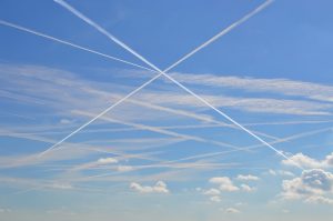
“…This is what chemtrails look like, you morons!”
And
“…What I find particularly interesting, as a veteran combatant of the climate wars, is the reluctance of my old, climate skeptical comrades to acknowledge the role of chemtrails, the use of Directed Energy Weapons and such like in generating extreme weather events.”
STRENGTH OF HURRICANES HELENE AND MILTON, AGAIN
Let’s delve into James Delingpole’s notion that the power of 2024’s Hurricane Helene and Hurricane Milton was man-caused because of chemtrails. In Part ONE, we saw that rather than climate engineering causing the sun’s Earth-heating power to decrease, Total Solar Irradiance has been increasing, as revealed from measurements at the surface.
My 2 November 2024 post shows satellite measurements, from at least 1985-2010, graphically demonstrate that cloud cover decreased significantly over that period. That same post describes that a “Sahara Dust Layer” was in place over the Caribbean Sea in 2024, reducing convective cloud formation and allowing even more sunlight to heat the ocean waters there. There is no doubt that SUNLIGHT (Figure 3 of that post) heats sea water, not more radiation from the infrared from more atmospheric <CO2>, as the global warmers contend.
Doubtlessly, the power of 2024’s Hurricanes Helene and Milton was derived from the very warm, even hot, temperatures of the Caribbean Sea late in 2024’s hurricane season. Less cloud cover means more sunlight over that water, and it is sunlight which warms ocean, lake, river and even swimming pool water.
These are the OPPOSITE of the effects alleged by the Chemtrail Alarmists, effects they say decrease the power of the sun to warm terrain and oceans. The Brits would say that the Chemtrail Alarmist-posited effects are the “wrong way ‘round’,” because they act to cool Earth and Ocean. But the 2024 Caribbean Sea was very warm, some even say hot, and evaporation from this heated water was the source of the copious cloud liquid water whose latent heat release powered the development of 2024’s very strong Hurricanes Helene and Milton.
ABOUT DELINGPOLE’S DIRECTED ENERGY WEAPONS COMMENTS
During my career in the Air Force as a Weather Officer I spent 4 years at the Air Force Weapons Laboratory studying the effects of the atmosphere on the ability of lasers and High Energy Lasers to be used as weapons. In that assignment, I built and tested a micrometeorological system to measure the atmosphere’s effects on the Air Force Laser tests there. After I retired from the Air Force, I spent another 10 years at the High Energy Laser Systems Test Facility at White Sands Missile Range, New Mexico. I was a Civil Service Meteorological Team Chief, developing the ability to measure and forecast the specific atmospheric elements which would affect the High Energy Laser beams being tested. I have decades of experience in this area of technology.
Defense Secretary for President George W. Bush and then for President Obama, Robert Gates, at Obama’s direction to impose severe Defense cuts, took the axe to the Air Force’s follow-on efforts, the Air Force’s Airborne Laser program, the ABL, in his August 2010 announcement of those cuts.
Delingpole seems to think that current US High Energy Laser systems are used malevolently, in his words, “the use of Directed Energy Weapons and such like in generating extreme weather events.”
But no such capability exists today. Present (2024) US Defense efforts to this end are characterized in this article. A good pull-quote summary is
“The Navy has shown interest in laser weapons across different vessels. Last year, it tested another system — the Solid-State Laser – Technology Maturation Laser Weapons System Demonstrator — on the San Antonio-class ship USS Portland. The service used the LWSD to disable a drone during an at-sea test in 2020.”
Delingpole talks about US defense lasers, “generating extreme weather events,” when National Defense Magazine describes the ability to “disable a drone.”
A quote from NASA astronauts, from decades ago “does not compute.”
There is an allied subject to describe here. Fifty-five years ago, in 1969, I was a participant in a successful operational military weather modification effort, cloud seeding over the Ho Chi Minh Trail of Laos. When conditions were favorable, that effort enabled us in the USAF to create multi-cloud enhanced rainfall from rain showers and thundershowers over the Trail. I am sure we were occasionally able to generate Mesoscale Convective Complexes where it rained from these showers over an extensive area for hours at a time, perhaps similar to what a typhoon might bring to that region. Whether or not that is an example of an extreme weather event is a value judgement. Truck Counts showed it certainly was a significant operational hinderance to the North Vietnam Army’s ability to transport weapons, ammunition, and other logistics necessities over the Ho Chi Minh Trail to their troops in South Vietnam.
CUT OFF LOWS SOMETIMES DISRUPT THE “SEASONAL” STORM PATTERN
Especially during the cool and cold seasons, low pressure areas, the storms that cause the frequent changes in weather, from wet and rainy to fair and dry, commonly occur in the middle latitudes of both northern and southern hemispheres. These are migrating lows, the mechanism for the earth to move warm tropical air poleward so that the equator to pole temperature difference stays between the commonly observed averages, season after season, year after year.
From time to time one of these migrating lows dips so far equatorward that it is cut off from it’s usual position within the Jet Stream. When this happens, the low slows way down and, if extremely deep, may even retrograde. So, instead of moving from west to east in the westerly direction it slows to a crawl and sometimes the whole system moves east to west a bit. Such systems are called “cut-off” lows.
It is not uncommon for cut-off lows to affect the region around the Iberian Peninsula, where Spain and Portugal are. These cut off lows even have their own name: “Cold Drops,” in Spanish, “Gota Fria.” The presentation graphics slides 131-134 displays records of seventeen such cut-off lows that have occurred since 1356 AD. Thousands have died from the floods following the heavy rains which occur during such cut-off low episodes.
VALENCIA, SPAIN’S FLOODING RAINS
James Delingpole ascribes the strength of the late October 2024 cut-off low which affected Valencia, Spain, and nearby localities to jet aircraft contrails, which he calls chemtrails. Wikipedia reported 230 deaths, but at this writing, 8 December 2024, the toll continues to increase slowly. Delingpole provides no specifics telling us WHY he attributes this particular storm to contrails. The same Wikipedia source reported that the Cold Drop of 25 September 1962 caused “between 600 and 1000 fatalities.”
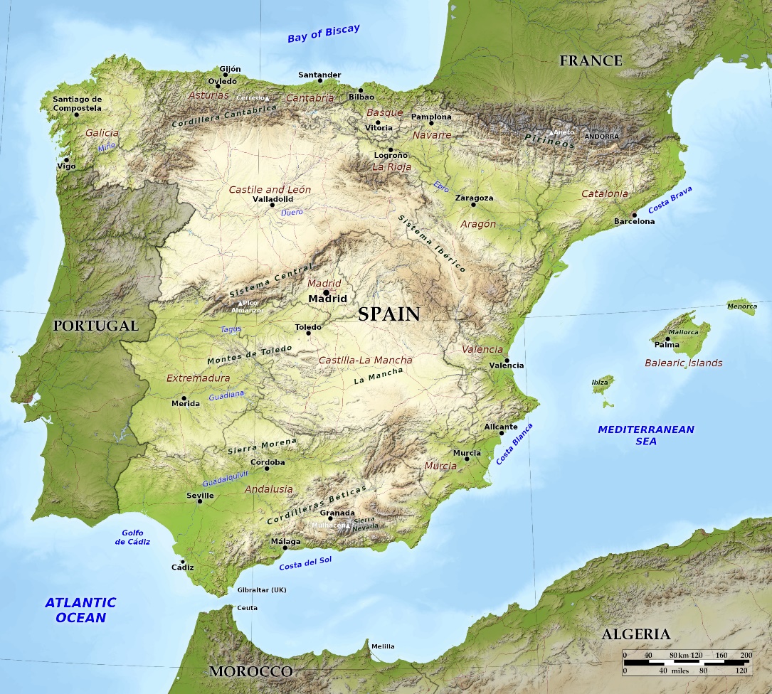
The large number of flooding events associated with cut-off lows cited above is directly attributable to the geography of Valencia and eastern Spain. Valencia is located right on the Mediterranean Sea, on a narrow coastal plain.
https://bluegreenatlas.com/spain.html

Figure 6 above shows the narrow coastal plain where Valencia is located and the mountainous terrain not far inland. This geography is the orographic set-up for large amounts of rain when deep low pressure over interior Spain brings moist air from the Mediterranean Sea, onshore, with strong winds from the east. The mountains’ slope acts as a wedge to force the moist air aloft. The moist air rises, cools, and water vapor condenses out in the form of clouds and copious rain. The history of devastating floods in Valencia and nearby regions, cited above, shows the late October 2024 Valencia flood is not an especially rare event.
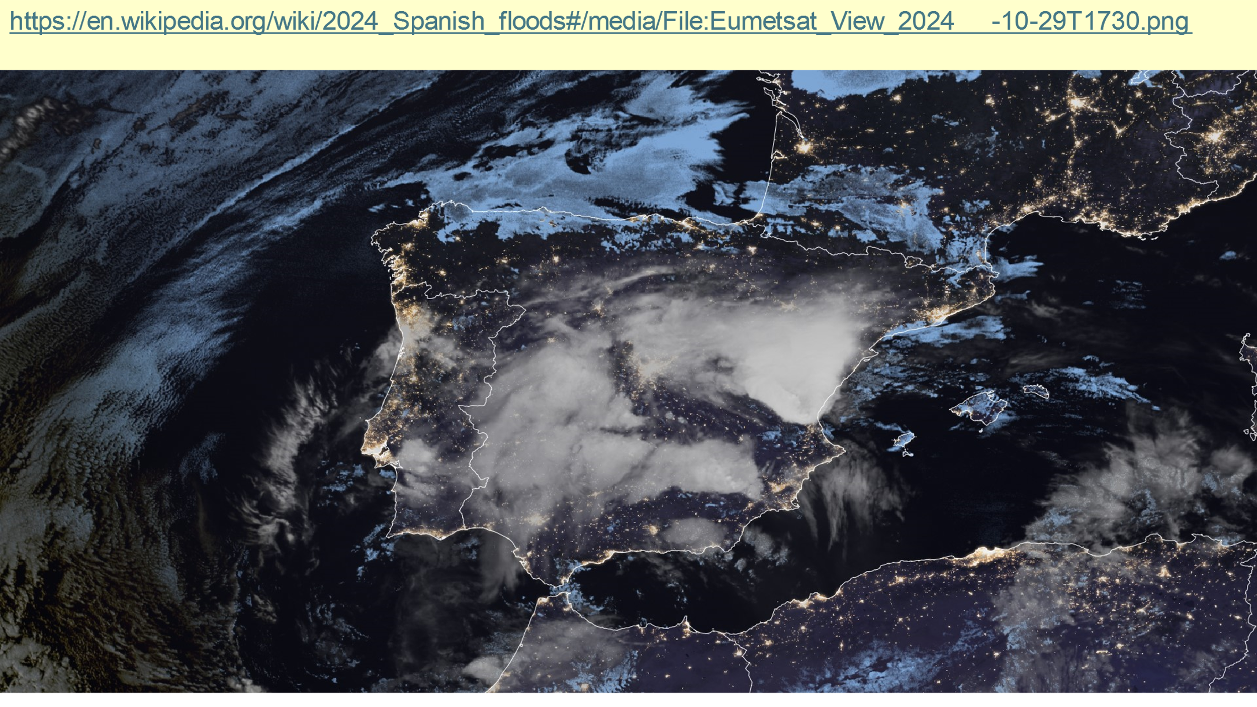
Figure 7 below, taken from Slide 120 of the presentation graphics, shows a 29 Oct 2024 nighttime view of the Iberian Peninsula and surrounding areas when Valencia’s cut-off low was in progress. Notice especially the pie-shaped bright white area of clouds, and the very sharp edges of that cloud mass on the south and the east side, the latter right over the coastal plain where Valencia sits. Those sharp edges and the very bright whiteness of that cloud mass are direct indications of ONE, the control by the terrain on the location of the strongest rainfall, and TWO, the intensity of the rainfall occurring at this moment. That bright white is an indication that very heavy rainfall is falling from the deep clouds there.

One message from this post is the geographical, physical, meteorological and observational data that flooding rains in and around Valencia are not an especially rare event. Records from 13 August 1356, going back even to before the Christian conquest of the Muslim invaders in 1492, under Phillip and Isabella, show strong storms and flooding in Valencia way back then. Delingpole shows no reasoning why aircraft contrails worked to make the late October 2024 cut-off low event especially strong, or stronger than previous such events.
US WEATHER RADARS, NEXRAD SYSTEMS, CAUSE MORE STORMINESS?
Among the silly claims by James Delingpole in Substack is this one:
“…truly bizarre behavior of the weather fronts gathering around those HAARP and NEXRAD facilities…”
HAARP (High Energy Active Auroral Research Program) was an experimental military research program since given to the University of Alaska but a search on it at the University of Alaska web site produces a “Page Not Found” result. To me this is an example of rather than HAARP being a weapon of war being used by the USA’s Government for weather control, it is a one-off project given to the university to further the education mission of perhaps graduate students and a professor or two.
NEXRAD is the name of the weather radar system described from their web site as,
“The Next Generation Weather Radar (NEXRAD) system is a network of 160 high-resolution S-band Doppler weather radars jointly operated by the National Weather Service (NWS), the Federal Aviation Administration (FAA), and the U.S. Air Force. The NEXRAD system detects precipitation and wind, and its data can be processed to map precipitation patterns and movement.”
NEXRAD data are automatically put on-line for use by forecasters, meteorological researchers and the public at large. The NEXRAD system is one heck of a lot better than the primitive FPS-77 weather radar I used when I was commander of the Weather Detachment at Davis-Monthan AFB from 1976-1979. But the FPS-77 was what we had in the 1970s and we used it to the best of our abilities to observe and provide warning of thunderstorms and rain events which occurred, especially during the Monsoon Season.
NEXRAD weather radars emit radio frequency waves and measure both the backscattered radiation’s strength and the Doppler shift of the backscattered radiation. The strength or power of the backscattered radiation received by the radar is related to the amount of rain in the beam path. The intensity of the backscattered radiation received by the radar is directly related to rainfall rate. This can be numerically integrated to indicate the amount of rain falling on the ground. Therefore, it is an excellent method to indicate whether flooding rain is occurring and is a basis for issuing flood and flash flood weather warnings to the affected area.
The backscattered radiation’s frequency (different from its intensity described in the previous paragraph) can be examined for Doppler shift. The first instance I know of where Weather Radar Doppler Shift was a research objective was Professor Louis Battan of the University of Arizona. Dr Battan described his work at an American Meteorological Society Chapter meeting I attended in Tucson, when I was stationed at Davis-Monthan AFB. Prof. Battan used a Doppler weather radar atop the Catalina Mountains to measure the speed of the rainwater drops coming out of the base of a thundershower. This principle is now used in NEXRAD’s operation, but with the radar beam pointed horizontally.
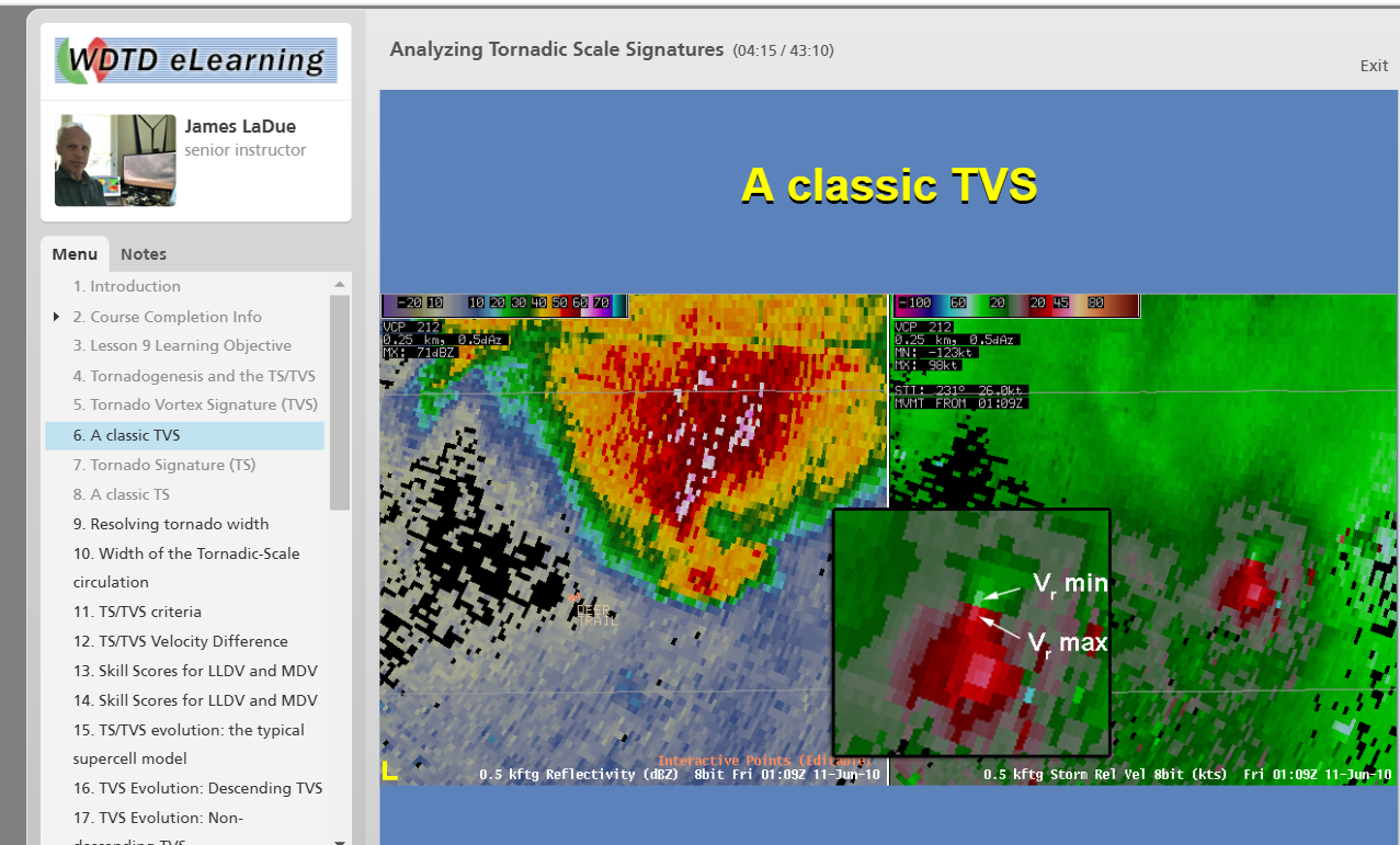
In Doppler mode, NEXRAD can and does measure the speed of water drops moving toward and away from the radar. This is the radial velocity. When a couplet of incoming and outgoing radial velocity returns is received by the radar early in a storm’s history, it indicates rotation of the drops in a circulation in the clouds. This is a precursor of an incipient tornado, and the basis for many explicit forecasts of tornadoes by forecasters using those data. Later in storm development, the radial velocity couplet indicates a tornado circulation extending to the ground and in-progress. This characteristic couplet is called a Tornado Vortex Signature, often TVS. Forecasters look for the existence of this couplet of radar returns showing the close proximity of returns showing Doppler shifts toward and away from the radar, indicating rotation. This is shown in Figure 8 below, with the close proximity of the red and green returns on the display.
An example of a TVS, Tornado Vortex Signature, from an NWS training video is below in Figure 8.
https://training.weather.gov/wdtd/courses/rac/severe/tornadic-signatures/presentation_html5.html

James Delingpole’s statement, that these NEXRAD facilities are causing
“truly bizarre behavior of the weather fronts gathering around… NEXRAD facilities…”
is in itself just not credible.
From my course in Radar Meteorology at Texas A&M University in 1964, weather radars evolved from the use of radar in the UK to track German ships off the coast of the UK in WW2.
The operators of those UK-based radars in the early 1940s noticed echo returns from rain and rain showers in addition to those of the ships they were tracking. Weather radar as it has developed in the subsequent years now offers the ability to track rain showers, thunderstorms, areas of heavy rain, and even now the Tornado Vortex Signature. So today we have for the first time, a peek at nascent tornadoes while they are still developing in the clouds. This tool enables near real-time pinpoint forecasts of tornado activity and the potential to save lives of those in its path.
But now we have James Delingpole claiming that these observing tools are nefarious instruments which alter the behavior of “weather fronts.” In reality they are instruments whose purpose is to alter the behavior of citizens in the line of potential harm of destructive rotating winds so as to alert, warn, and protect the lives of those in danger.
Let me engage in editorial comment: James Delingpole is an ignorant person who writes authoritatively about a subject of which he knows nothing.
CONCLUDING REMARKS
James Delingpole has been drinking the Kool-Aid being offered by the climate alarmists at Geoengineering Watch. James now thinks that aircraft contrails, which he and the other alarmists of that ilk call “Chemtrails” are a method of weather and climate control. I tried to dispel such ideas in this post, which explains in words, graphic examples, and specific descriptions why this is just not correct. It is a fantasy to believe that nefarious individuals are causing climate disruption because aircraft at about 35,000 ft MSL are emitting water from their internal combustion engines, causing contrails.
This process is common to all jets: combustion of hydrocarbon fuel to provide the thrust necessary as the aircraft go about their business of transporting people and freight in ordinary commerce and in the defense of the country.
Recently James Delingpole, once a climate realist who realized the global warming scam for what it is, now has seemingly been converted to a climate alarmist and written such in a post on Substack.
In my humble opinion, gathered in the course of academic endeavor, in work experiences over 49 years as Air Force Officer and civilian meteorologist, and in work on three continents, I conclude James has “drunk the Kool-Aid.” I show conclusively that James offers no proof of his assertions. I have offered here numerous examples of fact in subject areas where James’ writing is in error.
