
A Lack of Critical Thinking: Many in the Media got the Wrong Answer.
Robert W. Endlich
INTRODUCTION
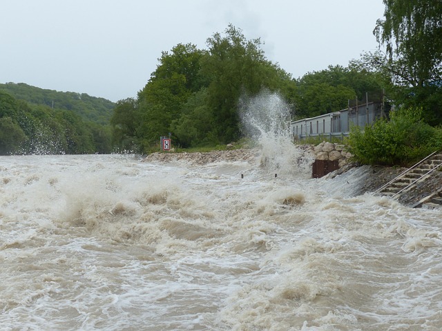
My heart sank when I found out about the loss of life, including many young girl campers, during a flash flood event on what should have been a joyous 4th of July holiday weekend along the Guadalupe River in Texas.
Although I’m originally from New Jersey, the Air Force, and later the Army, sent me many times to Central Texas, journeys which crossed Texas’ scenic Hill Country numerous times. When they were small, duty at Ft Hood frequently found me within 2 hours’ drive of Daughter Carol and Grandkids Daryl and Reina, and an excuse for me to take them on a ‘Saturday Adventure with Grandpa Bob,’ usually to drive and visit across the Hill Country. I know this area well.
This post describes Geography, Rainfall Records, Flood Records, pertinent NWS Forecasts (the Flood Watch, Flood Warnings, and Flash Flood Emergencies for this specific area), Media Hits and Misses, and some recommendations.
HILL COUNTRY GEOGRAPHY
Texas’ Hill Country consists primarily of Cretaceous limestones on the north and west of the Balcones Fault Zone, the Edwards Plateau, shown in Figure 1 below. The name Balcones comes from the Spanish for Balconies.
Visitors to San Antonio probably notice white limestone rock exposures on the hillsides along the northern regions of the city. A large park along San Antonio’s Austin Highway, Breckenridge Park, has on its northern side prominent cliff faces of the Cretaceous and frequently bare, limestone walls, some with water dripping down, resembling balconies.
The Japanese Garden in that park was excavated when the limestone was mined to provide raw materials for the Alamo Cement Company. Visitors to the San Antonio area should notice the Edwards Plateau/Hill Country quarries of the white limestone while driving on I-10 northwest of San Antonio, on I-35 northeast of San Antonio, and US 281 north of San Antonio.
South and East of the Balcones fault, lie the unconsolidated sedimentary formations of the Texas Coastal Plain, but North and West lie the mostly Cretaceous limestones of the Edwards Plateau, southern parts of Texas’ Hill Country.
Figure 1, taken from the diagram on pg. 114 of Roadside Geology of Texas, shows the locations of Del Rio, San Antonio, and Austin, Texas, the Balcones Fault Zone, and the uplifted Edwards Plateau; the brick-like motif symbolizes limestones (here, of Cretaceous age).
Note especially the small inset showing the cross-section. The A block, where the Edwards Plateau was uplifted, has surface elevations of 700-3000 ft MSL, and the B block, adjacent to the coastal plain, which had little vertical displacement.

RAINFALL RECORDS
NOAA keeps rainfall records for hydrometeorological design purposes in both map and tabular form. However, the tabular format in Christopher Burt’s Extreme Weather: A Guide And Record Book is better for blog posts, so I use that version, Figure 2, below. There are several items from that table which are of interest here, viz.,
-
-
- The most recent record-setting extreme rainfall amount in the USA, 43.00 inches for 24-hour rainfall accumulation, was in Alvin, TX, on 25 and 26 July 1979, when Tropical Storm Claudette came ashore and stalled near Houston, TX. That occurred 46 years ago.
- There were two rainfall accumulation records that were set in D’Hanis TX, on 31 May 1935, 15 inches accumulation in 2 hours, and 22 inches in 2 hours, 45 minutes, the latter a world record! These records were set 90 years ago. D’Hanis is 50 miles west of San Antonio on US 90, near the Balcones Fault Zone and only 20 miles from the Balcones Fault-associated volcanic intrusions at Knippa, TX.
- The 18-hour rainfall extreme for the USA, 36.4 inches, was set 9 Sep 1921, over a century ago, at Thrall, TX, some 40 miles northeast of Austin, TX, which itself sits astride the Balcones fault.
-
These four rainfall records, obtained from NOAA, and assembled by Richard Burt, show that the claims, recent warming is causing more extreme rainfall in recent years and at present, are demonstrably untrue.

Figure 3 below from the Austin Statesman is a map of Texas and surrounding states which shows the area around the Balcones Fault Zone nicknamed “Flash Flood Alley,” in dark gray shading. The darker gray shading shows the drainage area of the Guadalupe River.

FLOOD RECORDS
There are Newspaper Records of several Flash Floods on the Guadalupe River.
The Austin, TX, Statesman listed the 4 Jul 2025 flash flood and five other flash floods, the earliest from 1921, where flash flooding occurred in the Texas Hill Country along the Guadalupe River, with resultant publication in the Statesman.
There is a common thread from this list: the floods occur in the warmer months and are associated with old tropical systems or slow-moving clusters of heavy rain showers or thunderstorms over the Hill Country. Such floods are not that rare an event. It would seem as if the societies living in that area might take notice and organize themselves so as to prevent extensive loss of life from such events. Or so it would seem.

CBS News published a sequence of National Weather Service (NWS) Forecasts for this flood. Similarly, NBCDFW published the National Weather Service timeline of alerts issued ahead of the catastrophic Texas flooding
So, from these timelines of forecasts, below I list the specific forecasts for the Guadalupe River and Kerr County areas, issued by the NWS Austin/San Antonio office, below. Items in bold are my edits.
On Thursday, 3 July, at 1318, a Flash Flood Watch was issued by NWS Austin/San Antonio, in effect through Friday morning 4 July.
On Thursday, 3 July, at 2341, the first Flash Flood Warning for the event was issued for Bandera County, which is the county south of Kerr County, where the most destructive flooding occurred.
On Friday, 4 July 2025, at 0114 CDT Friday: Flash Flood Warning with a “considerable” tag was issued for Bandera and Kerr Counties. Flash Flood Warnings with the Impact-Based Warning tags “Considerable” or “Catastrophic” denote high-damage threats and will automatically trigger Wireless Emergency Alerts (WEAs) on enabled mobile devices, ensuring only the most life-threatening flash flood events prompt urgent public notifications. All alerts are also sent out over NOAA Weather Radio
At 0233 on 4 Jul 2025 the following was issued by NWS/Austin San Antonio on X, formerly Twitter, and was NOT included in either the CBS or NBC stories on this flood. Neither internet search nor the CBS or NBC results I quoted found this Flash Flood EMERGENCY post on X:
https://x.com/NWSSanAntonio/status/1941065290009453040
Here are the contents of that X post:


4 Jul 0335: Bandera and Kerr Counties — NWS sends a repeat of its earlier warning to the two counties, but in the warning language it adds:
“It is important to know where you are relative to streams, rivers, or creeks which can become killers in heavy rains. Campers and hikers should avoid streams or creeks.”
4 Jul 0403: Bandera and Kerr Counties —
“This is a PARTICULARLY DANGEROUS SITUATION. SEEK HIGHER GROUND NOW!”
and
“Move to higher ground now! This is an extremely dangerous and life-threatening situation. Do not attempt to travel unless you are fleeing an area subject to flooding or under an evacuation order.”
4 Jul 0403: — The National Weather Service in Austin/San Antonio issues a Flash Flood Emergency, stating:
“At 4:03 AM CDT, Doppler radar and automated rain gauges indicated thunderstorms producing heavy rain. Numerous low water crossings as well as the Guadalupe River at Hunt are flooding. Between 4 and 10 inches of rain have fallen. The expected rainfall rate is 2 to 4 inches in 1 hour. Additional rainfall amounts of 2 to 4 inches are possible in the warned area. Flash flooding is already occurring.”
4 Jul 0435: First reports from Kerr County Sheriffs Office of flooding at low water crossings had 201 minutes of lead time.
4 Jul 0534: Kerr County — NWS sends a repeat of its earlier warning to Kerr County, which includes Camp Mystic.
“This is a FLASH FLOOD EMERGENCY for the Guadalupe River from Hunt through Kerrville and Center Point. This is a PARTICULARLY DANGEROUS SITUATION. SEEK HIGHER GROUND NOW!”
and
“Move to higher ground now! This is an extremely dangerous and life-threatening situation.”
Figure 6 has as background a time series of the water level of the Guadalupe River in Kerrville, TX, plotted in blue. Within the black-bordered boxes are the specific Flash Flood Warnings and Flash Flood EMERGENCIES issued by the NWS Austin/San Antonio, with red arrows pointing to the time those warnings were issued.
Note: 4 Jul 0435: First reports from Kerr County Sheriffs Office of flooding at low water crossings had 201 minutes of lead time.

In my prior life as a Weather Officer in the Air Force, I, and later, troops under my supervision and command, issued forecasts and Weather Warnings to Command Posts, Maintenance Work Centers, and other units having a stated need to receive warnings well prior to the occurrence of adverse weather conditions. This is called having desired lead time. I have direct experience in this part of operational weather support.
IMHO, the NWS forecast office for Austin/San Antonio did a great job warning their customers well in advance of dangerous deadly flood conditions. The problem is, there were no local government agencies working 24×7 whose duties were to warn the citizenry when the NWS issued warnings.
As CBS notes,
“There is no local emergency warning system for Flash Floods.”
and
“There were no alerts sent by local government officials in Kerr County or neighboring Bandera County, to its south; they were reliant on National Weather Service alerts.”
MEDIA HITS AND MISSES
MEDIA HITS:
CBS: “Timeline shows when emergency alerts warned of Texas flood disaster,” https://www.cbsnews.com/news/texas-flood-emergency-alerts-timeline/. A Telling sentence from this CBS report: “There were no alerts sent by local government officials in Kerr County or neighboring Bandera County, to its south; they were reliant on National Weather Service alerts.” <Bold added>
NBC: Here are four telling quotes from this NBCDFW story,
ONE: “The National Weather Service shared a timeline of alerts sent ahead of catastrophic flooding in Texas after an NYT report questioned whether staffing shortages may have made it harder for forecasters to coordinate responses with local emergency management officials.”
TWO: The NWS said that on the morning of July 3, the office in Austin/San Antonio held forecast briefings for emergency management * and issued a Flood Watch that afternoon. The NWS said Flash Flood Warnings were issued on the night of July 3 and in the early morning of July 4, “giving preliminary lead times of more than three hours before warning criteria were met.” <Bold added>
* This quote is from Texas Monthly Magazine “On Friday, <4 July, Lt Gov Dan> Patrick reported that a high-level Texas Division of Emergency Management official had “personally contacted” county judges and mayors in the area.
“Yesterday <3 Jul> morning, the message was sent,”
he said.
“It is up to the local counties and mayors under the law to evacuate if they feel a need.” <brackets and Bolds, my edits>
THREE: Local NWS office had extra staffers <Bold headline in original>
“…There were extra people in here that night, and that’s typical in every weather service office — you staff up for an event and bring people in on overtime and hold people over,”
Runyen said.
FOUR: Kerr County has no flood warning system <Bold headline in original>
“Officials in Texas are facing growing scrutiny over a lack of a reliable warning system in the area.”
Wall Street Journal: https://www.wsj.com/opinion/a-flash-flood-of-failures-in-texas-camp-mystic- (Subscription needed, but copy available here Slide 89) by USC Engineering Professor Costas Synolakis.
Quoting Professor Synolakis:
“The National Weather Service issued flood watches on July 3 and escalated to flash-flood emergencies in the early morning of July 4. Authorities sent cellphone texts, but communities were asleep when alerts arrived, many campers didn’t have cellphones, and most locals lacked sirens or robust notifications to wake them.”
MEDIA MISSES
New York Times Headline https://www.nytimes.com/2025/07/05/climate/texas-flood-climate-change.html (behind paywall):
“As the World Warms, Extreme Rain Is Becoming Even More Extreme”
This notion is pure BS and represents a splendid example of yellow journalism in the New York Times. The extreme rainfall records for this area of Texas occurred decades before any claims of warming climate effects, and are:15 inches rainfall in 2 hours, D’Hanis, TX, 31 May 1935, 22 inches in 2 hrs., 45 minutes, D’Hanis TX, 31 May 1935, and 36.4 inches in 18 hrs., Thrall, TX, 9 Sep 1921.
American Progress Headline: “The Lasting Threat of Trump’s Cuts to NOAA and NWS on American Communities” https://www.americanprogress.org/article/the-lasting-threat-of-trumps-cuts-to-noaa-and-nws-on-american-communities/
A sub-headline says, “The Kerr County flood was made worse by climate change,” and in that paragraph, this: “More than 30 centimeters of rain poured down in a three-hour stretch…” Thirty Centimeters of rain is 11.8 inches, but 22 inches fell in 2 Hrs., 45 min. at D’Hanis, Texas on 31 May 1935, more than 90 years prior according to the NWS records in print in Extreme Weather: A Guide & Record Book by Richard C Burt.
Another American Progress Sub-Headline from the same source: Climate change is making extreme weather disasters more frequent, more intense, and more catastrophic. But on our CASF.ME website, we post these data sets which contradict American Progress: https://casf.me/wp-content/uploads/2024/02/Top-Dozen-Graphics_updated.pdf
There are three specific data sets at that location which prove the American Progress story is full of hooey:
(1) Major Hurricane Frequency is down since the 1990s according to the data published by Ryan Maue,
(2) the US Count of Strong to violent tornadoes is down according to the data published by the Storm Prediction Center and analyzed by Heartland Institute’s “Climate at a Glance,” and
(3) after 100 years of climate change, the risk of climate-related deaths has approached zero.
Not to be outdone, Texas Monthly, in https://www.texasmonthly.com/news-politics/what-went-wrong-texas-floods/ came out with this headline:
“Downed Weather Balloons and Missing Gauges: What Went Wrong With the Central Texas Floods.”
From this article, this sentence:
“Other insiders have said the budget cuts may have played a role in forecasting errors.” <Bold added>
I say, WHAT Forecasting Errors?
As pointed out previously, and shown explicitly in Figure 5 above, the NWS issued a timely Flash Flood Watch the afternoon before, 3 Jul 2025, at 1334.
And, as shown in Fig 5 above, they issued a Flash Flood Warning for Kerr County on 4 Jul at 0114.
On X, formerly Twitter, the NWS issued a Flash Flood Emergency for the area at 0233, https://x.com/NWSSanAntonio/status/1941065290009453040
At 0403 the NWS issued another Flash Flood Emergency for South Central Kerr County.
This report from the Kerr County Sheriff’s Department: 4 Jul 0435: First reports from Kerr County Sheriffs Office of flooding at low water crossings had 201 minutes of lead time. <Bold added>
It is stunning to me that Texas Monthly curiously did not find this report from the Kerr County Sheriff’s Office saying there was well over three hours lead time from warning to occurrence of first flooding of the low water crossings.
And then, same article, Texas Monthly mentions “Forecasting Errors!”
The lack of critical thinking by Texas Monthly is in overabundance with their publication of this statement:
“State officials are blaming the NWS for undercooking its rainfall forecast,”
dwelling on the notion that original Flash Flood Watch indicated that up to 7 inches of rain might fall in the hours ahead. After the flood, storm totals of 12.2 inches were reported.
It seems to me that Texas Monthly is unfairly and unreasonably dwelling on the first estimate of up to 7 inches, forecast in early afternoon of 3 Jul 2025 in the Flash Flood Watch. They use this sentence:
“This does appear to have been an underestimate.”
To me the real problem is the Flash Flood Watch does not seem to have elicited much action on the part of local emergency managers. In another part of Texas Monthly’s story:
“On Friday, <Lt Gov Dan> Patrick reported that a high-level Texas Division of Emergency Management official had ‘personally contacted‘ county judges and mayors in the area. ‘Yesterday morning, <meaning Thursday, 2 Jul 2025> the message was sent,’
he said.
“It is up to the local counties and mayors under the law to evacuate if they feel a need.”
Texas Monthly devotes much to former NWS employee Victor Murphy, who took voluntary retirement in the DOGE (Elon Musk-led manpower reductions the prior months)-inspired cuts in NWS staffing. Murphy states and Texas Monthly seems to agree that the NWS reductions created weather sounding balloon launch reductions which adversely affected the forecast for that day:
‘This lack of data has adverse impacts on the quality of the forecast,”
Murphy told me.
“That’s a hundred percent due to DOGE. There’s no ifs, ands, or buts.”
To which I pull out my BS flag!
The Central Texas Flash Floods were caused by the interaction of the remnants of Tropical Storm Barry with the Hill Country terrain and the strong solar heating at this time of year, only 12 days past the Summer Solstice. The atmosphere over Missouri to Texas to the Yucatan Peninsula was tropical, not the normal middle-latitude conditions dominated by westerly winds, and reductions in balloon soundings over more poleward stations did not affect, nor could they affect the forecast in the tropics.
The NWS did an outstanding job in telling the Texas public of the danger in the atmospheric conditions that day, Watches, Warnings and Flash Flood Emergency Messages shown in Figure 6 below. The real issue is that rural Texas communities do not have and did not have 24-hour work centers to receive and disseminate Weather Warnings and Flash Flood EMERGENCIES. Seemingly everyone was asleep on this first day of the Independence Day Holiday weekend, and the NWS Warnings and Flash Flood EMERGENCIES went nowhere in Kerr County. No one was awake to alert the general public in Kerr County and along the flood plains of the Guadalupe River.
Figure 6 below is a graphic which enumerates the timely and specific Flash Flood Watch, two Flash Flood Warnings, and several Flash Flood EMERGENCY statements issued by the NWS Austin/San Antonio well ahead of the occurrence of the flash floods in Kerr County and along the Guadalupe River. Texas Monthly and others ignore the root cause of the drownings: Kerr County had no one on duty to react to the NWS warnings, despite the fact that Texas Emergency Management had apparently called leaders at the county level mid-day on Thursday 3 Jul 2025.

CONCLUSION AND RECOMMENDATIONS
The NWS Austin/San Antonio did an outstanding job of watching the weather and issuing three phases of warning to their customers in Central Texas: Flash Flood Watch, Flash Flood Warning and Flash Flood EMERGENCY.
Rural Texas has various “communities,” not quite towns, and no strong top-down leadership function working 24×7 outside cities. Despite the successful execution of the weather part of the mission by the NWS, the good warnings provided were not passed to those citizens who needed the warnings. “Kerr County has no flood warning system <Bold headline in original>
“Officials in Texas are facing growing scrutiny over a lack of a reliable warning system in the area.”
As stated above, part of the solution lies in creating some sort of 24-hour government or government-led organization which would pass weather warnings and flash flood emergencies to residents of these communities.
In one local community, Comfort, Texas, a Fire Department employee, Daniel Morales, took the initiative to create a Flash Flood Warning system and getting it put in place, for about $60,000. This locally-devised solution is shown in Figure 7, below.

The success of Daniel Morales in Comfort, TX, stands as a marker where local initiative and persistence has succeeded. This is in contrast where failure of the previous effort in Kerr County occurred, because monies and priority to succeed at the County level were not available to the decision makers at the time.
There are lessons to be learned.